Tuesday, June 25, 2019

Moving the Historic Canal Boat Shad to Lion Salt Works Museum


Until recently my wife and I spent the winter months in the UK and the remainder of the year in an area in the States just outside Boston.  Ever since 2012 I have volunteered at the Ellesmere Port Narrow Boat Museum while visiting family in Liverpool.  Last summer we sold our home in the States and on Christmas day moved full time to the UK.  As a volunteer I spend most of my time doing joinery work in the museum boatyard.  At the moment I am working on a boat hatch for one of the museum boats and frequently called on to help with various other joinery projects associated with exhibits or facility repairs.

With having only volunteered at the museum during winter months I never had the opportunity to take part in any of the boat activities which typically take place during the warmer weather.  Because of this I requested permission to join a team during part of their task to move one of the museum's boat called Shad to an event to be held at the Lion Salt Works festival. Shad is a historic working boat once used to transport goods on the canals in England prior to the existence of highways for motorized vehicles.  

On the day before the trip I drove from my home in the city center of Liverpool as I was planning to meet the boat museum team the next morning for the segment of the trip from Barbridge to the Lion Salt Works. This segment of the trip was about 14 miles along the Shropshire & Union Canal which would take us about 8 hours due to the number of locks we had to traverse.

Driving in the UK is a new experience for me as I have not fully adjusted to driving on the other side of the road yet.  I decided to stay overnight near Broken Cross to avoid the morning traffic rush so that I would be well rested as the canal trip the next day would be quite long and followed by a trip to pick up my car that was left at the starting point of our trip and a then a drive back to Liverpool

The museum team was headed up by Martyn Kerry and was assisted by Alex De Lie as well as several museum volunteers. Early Thursday morning Alex, Martyn and Sue Philips left Barbridge and met up with Jen De Lie, Peter Clark and myself at the Venetian Marina for the next leg of the Journey to the Lion Salt Works just outside Northwich.

Shad moving through the Bainbridge Lock with Alex De Lie at the helm

Although I have been fortunate to have experience on many types of small boats this was my first trip on a canal boat through the canal lock systems.

Shad is an interesting and historic canal boat that was used to carry goods on the canal when the canals were a working system prior to the advent of highways in the UK.  I learned that Shad’s hull was built for speed and is capable of traveling faster than the recreational boats that are used on the canal today.  The purpose for faster speed was to be able to move goods quickly and more efficiently.   Top speed for Shad is about 7-8 mph where the slower flat bottom canal boats typically travel at about 5 mph.

Jeni De Lie relaxing while waiting to assist with the next Lock

A trip of this kind justifiably requires an experienced crew to move museum boats so I felt very fortunate to have been able to join the crew during their efforts to move Shad to the Lion Salt Museum.

Peter Clark is a new volunteer at the museum who was on board to learn lock operations and to assist with moving Shad to the Lion Salt Museum

The purpose of the trip was to bring Shad to the Lion Salt Works Heritage Transport Festival to give attendees the chance to learn more about the boat museum and one of the historic boats in the museum collection.  Two weeks later Shad was scheduled to be transported to Lymm for the annual Historic Transport Day by a team headed up by Martyn.

Because of the logistics and duration of the events Martyn and Sue accompanied Shad with their personal boat Cherokee which serves as their temporary home. I had a chance to sit in the bow of their boat for a portion of the trip to just relax and enjoy the fantastic scenery.  I can easily understand why many enjoy canal life as it is very relaxing and therapeutic. Martyn and Sue have a beautiful boat with sleeping quarters in the stern area, very comfortable living quarters in the middle with two very comfortable chairs for relaxing. There is a small sitting area at the bow that can be covered during periods of rainy weather and which is the area I positioned myself during part of the trip.   


Cherokee owned by Martyn Kerry and Sue Philips.  Martyn at the helm

After meeting the team at Barbridge I was given a short safety briefing by Martyn and issued a life vest that would self inflate should I have the misfortune of falling into the canal.  I am pleased to report I did not have the unfortunate pleasure of a canal swim.

I then loaded my foul weather gear onto Shad which fortunately was not needed, my camera gear and few cans of IPA for us to partake in at the end of our journey.  I should mention that the crew were well behaved and did not did dip into the supply of IPA during the entire trip however I cannot say the same for the photographer as there was one empty can when mooring the boats at the end of the day.

Although I have volunteered at the museum for a number of  years I never worked any of the canal locks.  On this trip we passed through about 15 locks so I had a chance to learn a bit about the process from Jen, Peter and Sue who are experienced hands with lock operation.

This was a great day to travel the canal as the weather was perfect and there were lots of waterfowl tending their young ones that were obviously only days old.  We also passed through several farms where cattle were grazing some of which were nursing their newborn.  The bird life and animal life along the canal was amazing. 


The architecture along the canal was interesting too.  Some of the locks had lock keeper homes and in several locations very beautiful private homes were erected all of which added to the beauty of the canal.  Probably one of the most interesting homes we passed belonged to a former lock keeper named Maureen Shaw. The lock is located in Middlewich and officially is named the Wardle Lock but more affectionately called “Maureen’s Lock”.    Apparently when Maureen passed away in 2012 her coffin was transported on the canal to it’s resting place in Middlewich.

Maureen’s Lock, Middlewich

During the trip we passed through historic Middlewich which was the only town we passed through.  Middlewhich is worth an overnight stay for anyone traveling the canal.  For those who are only passing through there are several pubs along the canal where it is possible to moor for a few hours to have lunch and a pint before moving on.

Shad passing through Middlewich

We passed through several large working farms.  A few farms raised milk cows, others raised beef cattle and others appeared to be agricultural probably growing animal feed or rapeseed grown primarily as a fuel additive and vegetable oil.

One section of the canal that is not too far from Middlewhich was recently rebuilt.  The stretch of canal that was repaired is on high ground and when the wall of the canal failed it completely emptied that section of the canal flooding the valley below.  Fortunately there were locks about a mile apart which prevented the breach from being more serious than it was.

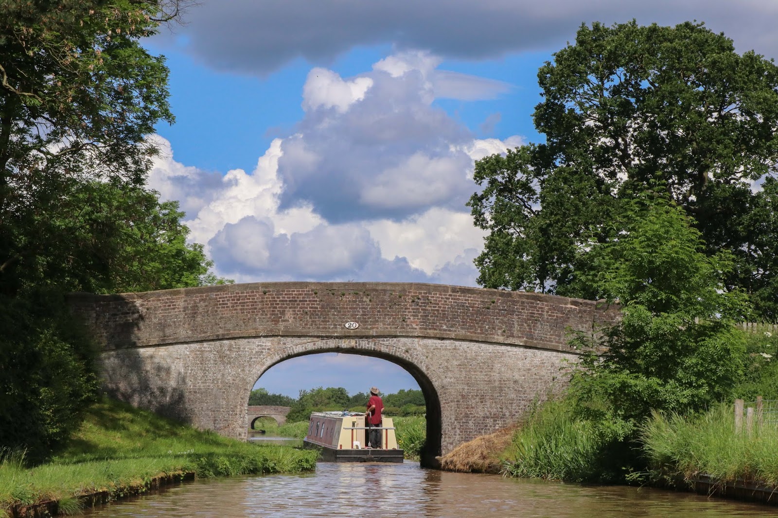
Bridge #20 - One of the many bridges that cross the canal.

The stretch of canal between Middlewhich and Broken Cross passes primarily through some very beautiful and peaceful farmland.  This section of the canal did not have any locks to navigate as the land is relatively level. 

It was a beautiful warm spring day for traveling the canal

The following day Martyn, Sue and Alex proceeded to the Lion Salt Works from Broken Cross in preparation for the weekend festival.  

Martyn and Sue on their way to Broken Cross

For more pictures Moving Shad to Lion Salt Works click here > > > > Moving Shad


Monday, February 16, 2015

Bidston Hill


Bidston Hill is about 100 acres that contains historic buildings and ancient rock carvings. It is located on the Wirral Peninsula, near the Birkenhead suburb of Bidston, in Merseyside, England. With a peak of 231 feet, Bidston Hill is one of the highest points on the Wirral. The land was part of Lord Vyner's estate and purchased by Birkenhead Corporation in 1894 for use by the public. Ref Wikipedia

GPS Tracks and Waypoints to Bidston Hill   LINK
Note:  When you click on the link above you will have access to two files that can be downloaded.  One file is in the format that can be downloaded and entered into your GPS software and the other file can be downloaded and opened in Google Earth.


View of Liverpool from Bidston Hill


In order to get to Bidston Hill from Liverpool I traveled by Merseyrail from the James St station to the Bidston station which is about 1/2 mile from the northern entrance of the park. Alternately it is possible to drive to the park where there is parking at the east side of the park at Tam O'Shanter Farm or by taking the 437 bus that passes every 15 minutes. The bus stops are at the south end of the park on Upton Road. I entered the park from the north where I followed a road at the base of the hill that passed several residences which joined a trail leading to the top of Bidston hill. At the top of the hill I first came to the Bidston Lighthouse and Bidston Observatory. Walking a little further is a restored windmill located a short distance from the lighthouse. There is a spectacular view of Liverpool to the east and to the west there is a not so clear view of the bay that the Mersey empties into. The lighthouse sits about 2 miles from ocean. At first it seemed odd that the lighthouse was so far inland however with it sitting so high this made it easier for mariners to locate it from further than if it was located at sea level.

There are a number of trails throughout the park however I decided to walk the length of the park and exited at the south end of the park where I took the return bus to Liverpool.

The trails are easy walking particularly if entered from the south as it would not be necessary to do much uphill climbing. Entry from the north is an easy uphill climb. Although there is a parking area at the eastern side of the park for those who choose to drive. I did not actually explore that area.

There has been a lighthouse on Bidston Hill since 1771. Being more than two miles from the sea, it depended on a breakthrough in lighthouse optics, which came in the form of the parabolic reflector, ...... The reflector at Bidston Lighthouse was thirteen-and-a-half feet in diameter, and the lamp consumed a gallon of oil every four hours. The present lighthouse was built in 1873 and was operational until sunrise on 9 October 1913. Bidston and Leasowe Lighthouse together formed a pair of leading lights enabling ships to avoid the sandbanks in the channel to Liverpool.


The Bidston Lighthouse


The Bidston Windmill replaced a wooden mill that was destroyed by fire in 1791, and was used to grind wheat until about 1875. However it is believed that there has been a windmill on this site since 1596. After falling into disuse it was bought and restored from 1894


The Bidston Windmill


The Bidston Observatory sits on the ridge of the hill watching over the Windmill, Park Wood and Bidston Village. The Observatory was built in 1866 when Liverpool Observatory had to relocate due to the expansion of Waterloo Docks. The building is made using the stone mined during the creation of the cellars. Bidston Observatory was important during the Second World War and predicted the tides for the D-Day landings amongst other things. The telescopes housed in the observatory, were used to watch planetary bodies in order to calculate the exact time. The exact time was needed for nautical navigation and was transferred to ships in the dock by the firing of the one o’clock gun.


Bidston Observatory

Monday, August 11, 2014

Beatles Early Years

Percy Phillips Recording Studio which is the center unit 
and is located at 38 Kensington St in Liverpool.

The recording studio that recorded The beatles first record is located not too far from the city center.  The building of terraced homes where the recording studio was located still stands and appears to be a home that is in use today.


Home of Brian Epstein located at 197 Queens Drive in Liverpool

The Rat & Parrot Pub is the former location for the 
Music shop owned and run by Brian Epstein

The home of Brian Epstein who was their first promoter still stands today.  The music shop Brian Epstein ran in the city center still stands also but has been renovated and is now a pub called The Rat & Parrot which appeared to be shut down at the time of this post.


Casbah Coffee House located in the West Derby area of Liverpool

The Casbah Coffee house where the Beatles often perfomed is located in the West Derby area of Liverpool. The Casbah is actually a residence still standing today and owned by Pete Best who was the drummer for the group that was called the Quarry Men and before the group were known as the Beatles.  Pete was replaced by Ringo apparently because of a fallout between Pete and Paul.  Pete still lives in West Derby and has a winter home in Spain.  I am hoping to be able to meet him at some point when he is in the area as we also have relatives who live in the West Derby area and know Pete well enough to introduce me.


New England Lighthouses

Owls Head Light -  Owls Head, Maine

Over the past several years I have been collecting photographs of New England Lighthouses as I have sailed or driven along the coast from Connecticut to Canada.  My goal is to photograph every New England Lighthouse.  This has turned out to be a more difficult project than I anticipated mainly because many of the lighthouses are offshore and only accessible by boat.

I’ve been fortunate to have been invited by my close friend Peter to sail Downeast on his sailboat the Linnet a number of times and as a result was able to photograph some of the lighthouses in Penobscot Bay.
I do not know if I will ever photograph all the lighthouses along the New England Coast but I am determined to photograph as many as possible.  It appears that there are over 200 lighthouses along the New England coast and so far I only photographed about 30.  As is obvious, I have a long way to go before I can even say I have photographed most of the NE Lighthouses.

The first link below links to a slide show of the lighthouses I have been able to photograph so far.
Click Here to view a slideshow of the lighthouses

Sunday, February 23, 2014

The Beatles - Liverpool England


One of my  projects this winter is to visit some of the various historic places associated with the Beatles.  I've been coming to Liverpool since 1985 and have never taken the time to purposely visit any of the sights associated with the Beatles.  This is also the 50th year since the Beatles first visited the States and performed on the Ed Sullivan show.  This winter I made an attempt to visit some of the more popular and some not so popular locations associated with the Beatles.  Locations like the Cavern, Strawberry Fields and Penny Lane are on the regular Beatles tours yet there are many other sites not often visited.  The locations I concentrated on were those such as homes where they lived, Schools they attended and locations they worked into some of their songs.  There are a great many places where they performed around the city.  These are so numerous that I decided to save that for another project however I did include more popular locations like the Cavern and Casbah.

This project started by visiting the Central Liverpool Library that has, as you can imagine, just about every publication written about the Beatles. I cataloged information on places where they lived, schools they attended, locations they worked into their songs as well as various monuments erected that were in some way connected to the Beatles such as the Yellow Submarine.

When I started this project I had no idea as to how much work would be involved in putting it all together.  Identifying, locating and photographing each location was more involved than I realized it would be.  Before venturing to find a location I would try to select ones that were relatively close to each other.  Since I do not have a vehicle here I used local bus transportation to get to an area. When I located what I was looking for I would photograph it as well as the surrounding area and using my GPS identified the specific geographic longitude and latitude where it was located.  I categorized my information into several topics such as place of birth, location of their home(s), locations associated with their songs, monuments dedicated to the Beatles and some information associated with the group before they changed their name from the Quarry Men to The Beatles.  Because of the amount of information I gathered I decided to break up the information into several posts.  I will post each once I have gathered all the information I have been able to gather on each topic.

It seems most appropriate to first write about where each of the Beatles were born.

Their Birthplace - Ringo and George were born at home while Paul and John were born in Liverpool hospitals.  The original section of Walton Hospital has been converted to apartments where Paul was born. The hospital John was born in was converted to a dorm for Liverpool University. Both still stand today.  The home Ringo was born is is now vacated and was ready for demolition  as a result of a regeneration project of the area where it is located however due to strong opposition the street will be renovated.  The home and the street where George was born still stands today.

Former Liverpool Maternity Hospital where John Lennon was born

124 Mount Pleasant St, Liverpool is the birthplace of John Lennon. John was born on 9th October 1940  in a second floor ward of the hospital. Today the building is used as a dormitory for the Liverpool University.


Birthplace and boyhood home of Ringo

Ringo (Richard Starkey) was born the 17th of July 1940 at 9 Madryn Street, Liverpool and childhood home of Ringo Starr, however, after his parents divorced he spent most of the time in his grandparents home at no. 59 on the same street. The homes on this street were scheduled to be torn down but due to strong opposition the street will now be renovated.


Birthplace of George Harrison

174 Mackets Lane, Liverpool- George Harrison was born here on the 25th of January 1943 and lived here from 1962 until 1965.


Walton Hospital, birthplace of Paul McCartney

Paul was born here on the 19th of June 1942.  The hospital was later converted to apartments however at present (2014) the building does not appear it is being used for housing.


Wednesday, January 22, 2014

Plymouth - Day 4

Mt Batten Cliff
Today my plan was to walk east along the Coastal Path from where I was staying at the Boringdon Arms.  My first stop was to be Mount Batten and then to walk several miles to a point where there is a bus stop.  My plan was to take a bus if I was tired or as an alternative, walk back to my room cutting across farm land. Unknown to me at the time was that the bus stop was not active during the winter months.


Now for the rest of the story - The beginning section of my walk actually passed through several active boat yards along the waterfront before reaching Mt Batten.  I spent a little time exploring Mt Batten and took a few photographs before heading east.  I came to a point along the path where it was closed apparently due to a land slide and this is where my fun began.

The last point of my walk along the coastal path
A detour was marked directing walkers to take the highway for a distance before returning back to the designated foot path.  Instead of walking back onto the footpath where it was marked I decided to walk a little further to an old fort and then to take a 2ndry road back to the Coastal Path to continue my walk.  The 2ndry road I decided to walk on cut through the middle of a golf course.  I was a little nervous walking through this road with golf balls flying everywhere as it appeared to be ladies day on the golf course and there were several women groups playing golf that morning.  As I passed through the golf course I came to a point where there were signs all over the place warning visitors not to proceed as the road entered a military firing range.  In all honesty I think the signs should have been placed at the edge of the golf course as dodging golf balls was probably more dangerous with all those women golfers on the course that morning.  Needless to say, this was a bit frustrating as I must have walked a good mile to where I planned to join the Coastal Path and was within a few yards of the path and had to turn back which from my rough calculations was going to add a good 3 miles to my walk before I would be able to reach the bus stop and food kiosk I was headed for.  I finally reached the bus stop and as mentioned at the beginning of this saga the bus stop was not in use during the winter months.  (I will know better to check on busses a little more carefully next time).

By the time I reached the bus stop I was exhausted.  The walk was more difficult than I expected as well as being much further than I planned due to the detours I ended up taking.  It was lunch time when I reached this point and there were two vehicles parked near the bus stop.  One car was vacant but I could see the apparent owner walking his dog on the beach as he was the only one in sight.  The other vehicle was a delivery van that was occupied by a driver who was having his lunch.  I approached the driver and explained I was totally exhausted and asked if he was aware of any way I could get a ride back to my room.  He explained that he was not allowed to take passengers for insurance reasons so I thanked him for his help and decided to wait to see if I could hook a ride with the other person who was walking his dog on the beach.  While sitting on a picnic bench waiting, the delivery van driver walked over to me and commented that he could tell I was very tired and agreed to give me a lift close to where I was staying. I have no idea who this person was and there is no way I could ever get in contact with him to thank him for the lift as it would likely mean his job if his company learned he gave me a lift. Hopefully I can do the same for someone else one day.

Plymouth waterfront
 After being dropped off I had a short walk back to my room.  I had some lunch and rested for a while before heading out to explore the Plymouth waterfront.

The heart of Plymouth was just another port city but the waterfront was quite interesting.  Leaving the Inn that afternoon I followed the Coastal Footpath back to Mt Batten where there was a water taxi that took passengers across the bay to downtown Plymouth.  The water taxi departed every half hour and only had to wait a short time to catch the next taxi once I reached the dockside.  It so happened I was the only passenger on the boat and had an opportunity to chat with the boat captain on my way across the bay.  He detected my obvious Yankee accent and wanted to know why I was visiting Portsmouth as it was not common for tourists to visit Portsmouth this time of year.  He wanted to know if I was interested in visiting the dock where the Pilgrims departed for America and I mentioned that it was not in my plans and that furthermore I lived close to where the Pilgrims landed and never visited Plymouth Rock either.  He replied by saying I had no choice in the matter as we would be landing at the dock where the Pilgrims departed so I guess now I will need to visit Plymouth Rock to complete my journey.

Landing where Pilgrims last departed for America
I walked along the Plymouth waterfront taking a few photographs then jumped onto a bus back to the Boringdon Arms where I was staying that evening.


This was my last day in Plymouth as I would be picked up the following morning by Bernard for the drive back to Liverpool.  It was an enjoyable trip even with a some excitement tossed in to keep things interesting for me.

Tuesday, January 21, 2014

Dartmouth to Plymouth - Day 3

It was day 3 of my trip to southern England and today it was time for me to make my way from Dartmouth to Plymouth where I would be staying for 2 nights.  As I did a fair amount of walking the day before it was a welcome change as I would be taking the coastal bus from Dartmouth to Plymouth.

Rainbow over Plymouth

The bus that traveled the coast was a double-decker bus and I managed to sit in the front row where I had a birds eye view of the countryside during my journey to Plymouth.

The bus terminated at the city center of Plymouth where I was able to transfer to another bus that would take me to the Borington Arms where I would stay for two nights. I was welcomed by the owner who showed me to my room which overlooked Plymouth harbor.  The Borington Arms is well located as it is actually located along the Coastal Path which I planned to walk and not too far from the passenger ferry to the downtown and harbor of central Plymouth.

More photographs from my stay in Plymouth - Click Here

This map shows where Dartmouth and Plymouth 
are located along the southern coast of England

Close up view of the bus trip from Dartmouth to Plymouth


The Borington Arms